

OSM 3D in XNavigator
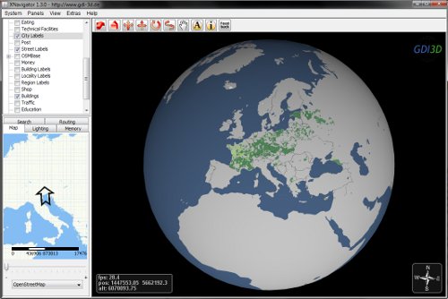
With XNavigator you can explore the virtual 3D model of the World. The software contains many features that were developed within the project GDI-3D.de. XNavigator downloads all 3D data for landscape, road, buildings, labels, and POIs from the W3DS. It can also connect to a number of other OGC services such as WMS providing the overview map, OpenLS Geocoder for searching for locations, and OpenLS Directory Service for searching for facilites and Points of Interest. An OpenLS Route Service for 3D-Routing including driving and walking directions has been integrated recently. The 3D routing adopts the technology from www.OpenRouteService.org. Additionally dynamic sensor measurements can be embedded and vizualized via a Sensor Observation Service (SOS) such as water levels, air pollution data (German Federal Environmental Agency) or, in the near future, current meteorological data (DWD). You can even adjust the illumination depending on date and time (Solar Settings).
The service showcases what can be done by combining OpenStreetMap (OSM) vector data, and SRTM elevation data. The OSM landuse areas have benn integrated into the terrain, buildings have been generated making assumptions on their height.
The software is completely based on Java and Java3D. For the 3D Graphics OpenGL hardware acceleration is used as well as specific software optimizations.
System Requirements:
1. min 1,5 GB RAM, recommended 2 GB RAM or more
2. Dual Core Processor
3. dedicated graphics card with at least 256 MB VRAM, OpenGL version 1.2 or higher
4. Internet connection with 4000 kbit/s or faster
5. Java Virtual Machine, version 6.0 or higher, preferably from Sun. Download here: http://java.sun.com/javase/downloads/index.jsp and install the Java Runtime Environment (JRE)
For best 3D performance we recommend to update the video driver to the latest version. Please visit the homepage of your notebook brand or the video chipset manufacturer, e.g. nVIDIA or ATI.
Download:
You can download the latest binaries here:
Download PageRead the readme.txt carefully, it contains important information for installing and configuring the software
Start via Java Webstart:
Alternatively, XNavigator can be started directly from your browser using Java Webstart. The necessary software components are downloaded automatically, only Java has to be intalled. If you experience slow frame rates (actual frame rate does not match the displayed fps), try to download and install the software. For best performance we recommend not to use Webstart.
For Java Webstart, we offer 2 different pre-configured profiles. The settings for these profiles affect the overall visibility (distances at which objects can be seen), and hence the volume of data that will be transmitted, and the memory footprint. The profiles were tested against the specifications described below. If the profile doesn't work, please tell us using the feedback form.
|
|
Support:
In the Wiki you can find comprehensvie information on how to operate and configure the software and on troubleshooting.
Help:
If you have questions about the handling of the program please take a look at the instruction manual first.
Feedback:
If you have feedback, suggestions, comments or further questions about the project or the technology, feel free to use the feedback form or write an E-mail to schilling@uni-heidelberg.de.
Terms of Use:
All data that was derived from OpenStreetMap is under the Creative Commons Attribution-Share Alike 2.0 License .
The SRTM height data was provided by CGIAR.
Partly map tiles courtesy of MapQuest
.
The SRTM height data was provided by CGIAR.
Partly map tiles courtesy of MapQuest ![]() .
Aerial image tiles courtesy NASA/JPL-Caltech and U.S. Depart. of Agriculture, Farm Service Agency
.
Aerial image tiles courtesy NASA/JPL-Caltech and U.S. Depart. of Agriculture, Farm Service Agency
All software that is provided through our services is property of the Chair of Cartography and is not allowed to be analysed (every kind of hacking, decompiling, reverse engineering) or built into other systems without explicit approval. By software we understand all programs that can be downloaded from our servers and that are needed for the use of our services, as well as all server programs which are installed on our servers and which are providing data and services to use. If you wish to use screenshots in publicatons, journals, press releases, news letters, blogs or for similar purposes we thank you for mentioning our project www.osm-3d.org.
2012 University of Heidelberg, Department of GIScience, GIScience